MySatellite 2.3

It can download and combine every map, terrain or satellite tile between two chosen Earth coordinates into one high resolution image.
Rating
Your vote:
Latest version:
2.3 See all
Developer:
Download
Demo
Used by 2 people
Info updated on:

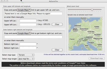
MySatellite can download and combine every map, terrain or satellite tile between two chosen Earth coordinates into one high resolution image.
Downloaded maps can be printed or exported to your Java (J2ME) enabled mobile phone (newer Sony Ericsson, Nokia, Sagem, Samsung, Motorola, LG phones support it).

Share your experience:
Write a review about this app

Video and screenshots (3)

Comments

User

Your vote:

Related apps

Google Earth
Google Earth
Free
rating

Google Earth gives you a wealth of imagery and geographic information.

Satellite Eyes
Satellite Eyes
Free
rating

Changes your wallpaper to the satellite view of your location.

Road Trip Effect
Road Trip Effect
rating

Utility that lets you share your trips.

Road Trip Effect Pro
Free
rating

Helps you create animated maps with your travels across the Globe

Terrain Bender
Terrain Bender
Free
rating

The app applies progressive bending to digital terrain models for cartography.

Related suggestions

Tags