Add geographical identification metadata to your images in JPEG, PNG and TIFF formats or modify already existent geotag information. Manually alter the latitude and longitude GPS properties or use a pin on the map to select the exact location. Export edited file metadata and screenshots of the map.
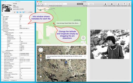
Photo GeoTag allows you to geotag JPEG, PNG and TIFF files, or change the existing geotag information. It's a great way to add or correct the GPS properties of any JPEG, PNG or TIFF file! Have a lot of photos with no GPS values? Now you can easily geotag them. Have photos with an incorrect GPS location? Now you can easily correct the GPS location. When you open a JPEG, PNG or TIFF image file with Photo GeoTag, the image and a map are displayed on a single window. If the image has GPS properties, a map pin is placed on the map representing the GPS location. To change the latitude and longitude GPS properties, simply drag the map pin to a new location. To add the latitude and longitude GPS properties, either specify the address, or the latitude and longitude values, or simply shift-click the map and a pin is dropped on the location you clicked. It
Comments