GeoTriple for Geospatial Imagery 2.0

Free Provides a collection of state-of-the-art geosciences software solutions.
3.9 
Rating
Your vote:
Latest version:
2.0.12 See all
Developer:
Geoforge project
Request
Download
link when available
Open source
Info updated on:

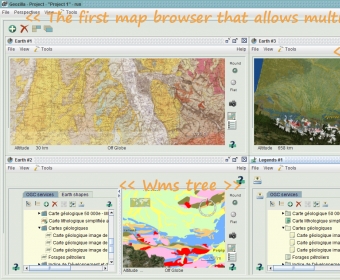
GeoTriple for Geospatial Imagery - also called GeoZilla - is an OGC services browser. Geozilla is software platform handling Web Map Services.

Main features:

- Store WMS (Web Map Services) servers and display their layers with earth viewers.
- Save the displayed layers state through viewers persistency.
- Create, import/export and display earth shapes (areas, paths, placemarks, pointsets).

Share your experience:
Write a review about this app

Screenshot (1)

Comments

3.9
Rating
77 votes
5 stars
19
4 stars
31
3 stars
27
2 stars
0
1 stars
0
User

Your vote:

Related apps

Qgis
Qgis
Free
rating

Create, edit, visualize, analyse and publish geospatial information.

Shapes
Shapes
rating

Easily create charts and model relationships on your Mac.

Marathon Red
Marathon Red
Free
rating

TC scenario for Marathon Infinity.

Archimedes Geo 3D
Archimedes Geo 3D
rating

Execute geometric constructions in three dimensions.

Fading Shapes
Fading Shapes
Free
rating

A screensaver that will draw different shapes on your desktop.

Tags