Magic Maps is a multi-purpose mapping tool so easy to use, it feels like magic.
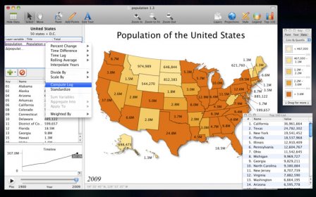
Do you work with data? Turn that spreadsheet into an interactive experience where states and countries light up according to values of interest, a timeline shows you how things have changed, and a Top 100 list presents the current standings. Magic Maps is a professional-grade tool for importing, analyzing and displaying time series data on a map.
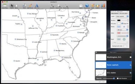
Do you have a creative side? Click the Crayon tool to start coloring in states and countries. Click the Pencil tool to add a few points of interest, and use the Text tool to label your map using the colors and fonts that suit your fancy. List all the places where you've planted your flag, or outline your future exploits. With Magic Maps, the world is your canvas.
Creating a map is the beginning. You can email your Magic Maps files to other Magic Maps users, or you can export your maps in many formats for use in presentations, articles, blog posts, YouTube, or data programs.
Magic Maps will help you find the insights in your spreadsheets or tell the stories of your travels. It will help you share your experience of discovery with colleagues, customers, readers, friends, and family.
Core features:
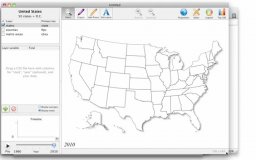
- Layer-based map presentation
- Multiple data fields per layer
- View a timeline of data totals and averages
- Click an entity to see its associated dataSelect multiple entities with a selection box or the Command key"Top 100" rankings for any data field
- Click "Play" to watch any map evolve over timeFlexible data import:
- Import data from CSV, KML, or ShapefilesCopy-paste data directly from a spreadsheet
- Manually edit data by clicking the mapSupport for UTF-8, Unicode, Latin-1, and Windows-1252 text encodingsVersatile map export:
- For print or presentations: Export vectorized PDFFor the web: Export PNG
- For email: Command-C copies the current image to the clipboard
- For spreadsheets: Export CSV data
- For YouTube: Export high-def QuickTime moviesFor Google Earth: Export KML
- For Google Public Data Explorer: Export Dataset Publishing Language (DSPL) Add custom points:
- Point-and-click to add a single point
- Batch CSV import of latitude and longitude
- Batch geocoding of U.S. place names (town or city) Add custom layers:
- Import KML or KMZ (including network links)
- Import ESRI ShapefilesLink data to custom layers
- Search for public templates at www.geocommons.com Fully customizable appearance:
- Use the crayon tool to color a simple map
- Choose colors to represent text categories or numeric ranges
- Move labels by clicking and dragging
- Leading lines automatically connect labels to their source
- Customize any fonts, colors, and sizesOptional drop shadows on shapes
- Adjustable movie playback speed Built-in math functions:
- Year-over-year change in absolute or percentage terms
- Sum multiple variables together
- Divide one variable by another
- Compute natural logarithm
- Scale by powers of 10
- Compute rolling average
- Compute weighted average Professional map projections:
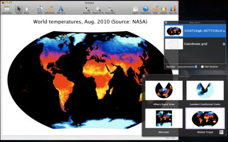
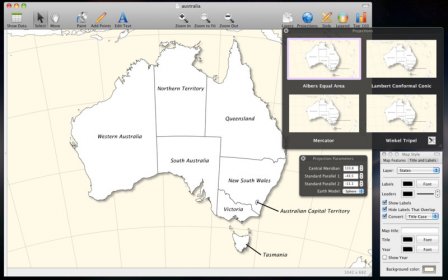
- Albers Equal Area
- Lambert Conformal Conic
- Mercator
- Winkel Tripel
- Instantly preview map projections
- Customize central meridian, standard parallels, and map rotation
- Support for spherical and ellipsoidal earth projections Basic GIS functionality:
- Count points within an area
- Aggregate point data within an areaDraw a "blast radius" of a specified distance around points
- Compute distance to nearest point on another layer
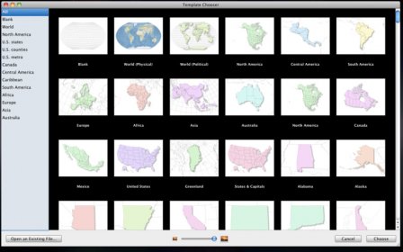
- Perform simple queries using Smart Layers Built-in geographic templates:
- Countries of the world
- U.S. states
- U.S. counties
- U.S. metro areas
- Link data against FIPS codes or state/country name

Magic Media Marker's main purpose is to process video files and make them pretty in iTunes and on your Apple Devices.

The Magic Pearl is stolen and it's up to Alice to find it in Mermaid Adventure.

Comments (1)