Locatr 3.0

Free Locatr extension reads geotagging information (latitude and longitude).
Rating
Your vote:
Latest version:
3.0 See all
Developer:
Jayanth Chennamangalam
Request
Download
link when available
Open source
Used by 1 person
Info updated on:

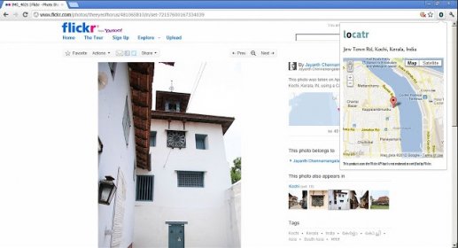
Locatr extension reads geotagging information (latitude and longitude) from the Flickr or 500px photo page in the current tab, and fetches the street address where the photo was taken, also showing a map of the area. Locatr is useful if you see an interesting photo of a place and want to go there yourself.

Share your experience:
Write a review about this app

Screenshot (1)

Comments

User

Your vote:

Related apps

ExifChanger
ExifChanger
Free
rating

Swiss Army Knife of EXIF utilities!

Fiddler
Fiddler
Free
rating

Objective-C libraries for calculating sunrise and sunset times.

G.Projector
G.Projector
Free
rating

Application which can transform an equirectangular map image.

WXtoImg
WXtoImg
Free
rating

The world's best weather satellite (WXsat) signal to image decoder.

Image Info Toolkit
Image Info Toolkit
rating

Easy to use application that handles text informatio

Tags