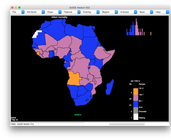
OzGIS is an extensive system for the analysis and display of geographically
referenced data. About 150 menus provide an enormous range of options for:
. importing data from databases, spreadsheets and Geographic Information
Systems (GISs) or downloaded from Census Bureaux or mapping agencies.
. processing data in preparation for display and analysis
. display of data as several different types of maps and diagrams.
. facilities to analyse displayed data and to manipulate the maps.
. Special support for site catchment analysis, location / allocation and
territory assignment.
The system can be used to analyze socio-economic and demographic data produced
by censuses and surveys and to support management decisions associated with for
example marketing, sales, site and personnel location, and advertising. Other
spatial data such as environmental data can be displayed.
Search for OzGIS on Youtube for tutorial / demonstration videos.
Google Earth Pro gives advanced business tools in addition to all the easy-to-use features and imagery of Google Earth.

Open source (LGPL) desktop application framework, built with Eclipse Rich Client (RCP) technology.


Comments