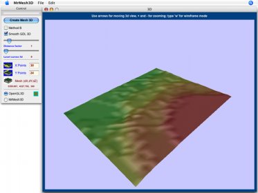
MrMesh3D 2 is now a powerful tool for creating 3D terrain models from bidimensional quoted plans.
MrMesh3D let you:
- open pictures for manual drawing and tracing of terrain data
- read quoted terrain points from x y z text files
- build and auto (or manual) quoting iso-level curves from polylines in dxf files
- enter manually x y z coordinates
- save your 2D drawing as dxf ascii file
MrMesh3D creates a 3d terrain model as:
- text files (XYZ)
- dxf 3D ascii files
- quickdraw3d metafile
- archicad gdl text file (or clipboard for copy-paste)
What's new in this version:
3d model is now coloured, according z coordinates3d model can now show level curvesit is now possible zooming to 3d model, using + and - keysminor interface fixes
Compact version of Navicat which provides basic and necessary features you will need to perform simple administration on a database.

Import OLM to Apple Mail, Thunderbird, Entourage, host of other emails clients.


Comments