Geotagalog 2.0

Why import ungeotagged pictures into iPhoto, when it's so straightforward to GPS-enable your favorite camera?
5 
Rating
Your vote:
Latest version:
2.0 See all
Developer:
Download
Shareware
Used by 9 people
Info updated on:

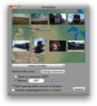
Geotagalog... Why import ungeotagged pictures into iPhoto, when it's so straightforward to GPS-enable your favorite camera? Geotagalog is a straightforward tracklog-based geotagging utility for iPhoto. By using GPX, NMEA, IGC or TCX files from a handheld GPS receiver to geotag your photos, you can work less to get more out of the Places feature in iPhoto '09.
As Geotagalog imports from a camera or disk, it uses sophisticated geotagging algorithms to match pictures to the GPS history in your tracklog. Location-enable your favorite digital camera with Geotagalog's simple workflow!

Screenshot (1)

Comments

5 stars
12
4 stars
0
3 stars
0
2 stars
0
1 stars
0
User

Your vote:

Related apps

Homedale
Homedale
Free
rating

Scan for Wi-Fi / WLAN Access Points and monitor their signal strength.

Geotag Photos Pro
Geotag Photos Pro
Free
rating

Geotag Photos Pro adds GPS capabilities to your camera.

SCUBAPRO LogTRAK
SCUBAPRO LogTRAK
Free
rating

LogTRAK is the software that allows Meridian to communicate with a computer.

GeoTag Desktop
GeoTag Desktop
Free
rating

GeoTag can add captured geo locations with your iPhone to the photos taken

Geotag Photos Pro 2
Geotag Photos Pro 2
Free
rating

Adds GPS capabilities to your camera and geotags your images.

Related suggestions

Tags