GeoNamesTagger 1.3

Free Update image EXIF, IPTC and XMP metadata with location-specific information.
4 
Rating
Your vote:
Latest version:
3.3.3 See all
Developer:
theoneandonlysepp
Request
Download
link when available
Freeware
Used by 9 people
Info updated on:

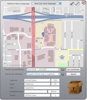
GeoNamesTagger is a tool to make geotagging of images easy. Set the right location, edit the Location information received to fit to your needs, and drop the image files onto the Dock-Icon or the applications drop area. The location can either be insert as a set of geographic coordinates, a search term* (e.g. a street address or place name) or directly set using a map.
What's new in this version:
Added app robustness if network connection not available Added png support Added status window message if non supported image or no image file was dropped Included ExifTool version 8.94 Fixed some minor issues

Screenshot (1)

Comments

5 stars
31
4 stars
31
3 stars
32
2 stars
0
1 stars
0
User

Your vote:

Related apps

Tagger
Tagger
rating

Application that auto tags audio files. It also supports batch tag editing.

Metadata Hootenanny
Metadata Hootenanny
Free
rating

View/editor for all the spiffy metadata you can put into Quicktime movies.

Pdf Metadata Editor
Pdf Metadata Editor
Free
rating

Allows modifying the metadata of single or various PDF documents.

Aperture Assistant
Aperture Assistant
rating

A small selection of Aperture Assistant's features.

iPhoto Tagger
iPhoto Tagger
rating

It turns your photos' metadata into iPhoto keywords and Spotlight comments.

Related suggestions

Tags