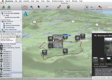
3D mapping application that allows you to transfer waypoints...
Create and download your own filters, like textures and visual effects.
SimpleDEMViewer browses DEM (Digital Elevation Model) data as pictures.
Create routes, tracks and transfer maps to mobile or GPS.
This interface enables the control over the angular acceleration on a plane.